


DJI Zenmuse L3 LiDAR Camera
DJI Zenmuse L3 LiDAR Camera
SKU:CB.202510103621
- Long-range LiDAR system: 950 m @ 10% (100 kHz) and 700 m @ 10% (350 kHz).
- Survey-grade accuracy: delivers 2–4 cm precision for mapping applications.
- High-efficiency mapping: covers up to 10 km² per flight or 100 km² per day
- Adjustable point-rate control: 100 kHz – 2 MHz to balance density and coverage.
- Configurable returns: 16 (100 / 350 kHz), 8 (1000 kHz), 4 (2000 kHz).
- Dual 100 MP Micro 4/3 cameras: generate orthophotos and colorized point clouds.
- Real-time point-cloud preview: measure points, lines, and areas in DJI Pilot 2.
- Compact low-power design: 1.6 kg payload draws only 64 W typical power.
- Rugged environmental build: IP54 rated for –20 °C to +50 °C operation.
- Streamlined workflow: integrates directly with DJI Terra and Modify.
- DJI Care Enterprise Plus: 1-Year coverage activated upon first use.
Couldn't load pickup availability


High-Precision 3D LiDAR Scanning
- Integrates advanced LiDAR sensor with high-resolution RGB camera for simultaneous 3D point cloud collection and visual imaging.
- Captures centimeter-level spatial data for complex terrains, industrial sites, and urban environments.
- Applications: Surveying urban infrastructure, 3D modeling of buildings, bridges, and industrial facilities.
Surveying & Mapping
- Supports real-time LiDAR data acquisition, precise georeferencing with onboard GNSS/IMU, and rapid point cloud processing.
- Enables generation of digital twins, topographic maps, and high-precision 3D models.
- Applications: Land surveys, construction site monitoring, urban planning, mining site mapping, and environmental assessment.
Infrastructure Inspection
- Combines LiDAR scanning and high-resolution imagery for detailed inspection of hard-to-access structures.
- Detects structural deformations, obstacles, and anomalies efficiently.
- Applications: Bridge inspections, railway monitoring, power line surveys, industrial facility assessment.
Construction & Progress Monitoring
- Facilitates frequent 3D scanning to track construction progress, verify as-built structures, and ensure quality control.
- Supports integration with BIM (Building Information Modeling) systems for planning, design verification, and reporting.
- Applications: Construction project monitoring, infrastructure verification, and site documentation.
Environmental & Industrial Applications
- Provides versatile LiDAR and RGB imaging for environmental surveys, forestry mapping, and industrial site management.
- Enables rapid aerial deployment in complex or hazardous areas where ground surveying is challenging.
- Applications: Pipeline monitoring, forest surveys, mining operations, and industrial site inspections.
Collapsible content

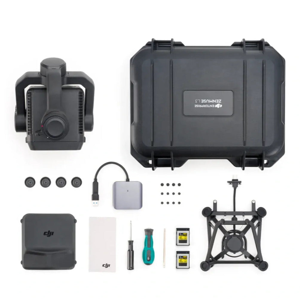
Packaging
- 1× Zenmuse L3 payload
- 1× Zenmuse L3 single-port gimbal mount, including shock-absorbing ball set (L3-compatible only)
- 2× CF-Express Type B memory card (1 TB each)
- 1× CF-Express Type B card reader
- 1× Screw tool set
- 1× Storage box
- 1× Lens cloth
- 1× M400 transport box inner liner (for L3 fit)
Specs
- Product Name: Zenmuse L3
- Point Cloud System Accuracy: At 120 m flight altitude – Vertical 3 cm (RMSE), Horizontal 4 cm (RMSE); At 300 m flight altitude – Vertical 5 cm (RMSE), Horizontal 7.5 cm (RMSE)
- Point Cloud Thickness: 1.2 cm @ 120 m (1σ); 2 cm @ 300 m (1σ)
- Combined Horizontal FOV (Dual RGB Mapping Cameras): 107°
- RGB Ground Sampling Distance (GSD): 3 cm @ 300 m nadir flight altitude
- Weight: 1.60 kg (without single gimbal connector); connector 145 g
- Dimensions: 192 × 162 × 202 mm (L × W × H)
- Power: 64 W (typical), 100 W (max)
- Supported Aircraft: DJI Matrice 400 RTK (with Zenmuse L3 single gimbal connector)
- Ingress Protection Rating: IP54
- Operating Temperature: −20 °C to +50 °C (−4 °F to +122 °F)
- Storage Temperature: −40 °C to +70 °C (−40 °F to +158 °F)
LiDAR
- Laser Wavelength: 1535 nm (Class 1 eye-safe)
- Beam Divergence: 0.25 mrad (1/e²)
- Spot Size: Φ 41 mm @ 120 m; Φ 86 mm @ 300 m (1/e²)
- Detection Range: 700 m @ 10% (350 kHz); 950 m @ 10% (100 kHz); 2000 m @ 80% (100 kHz)
- Wire Detection Range: 21.6 mm steel wire 300 m @ 100 klx (350 kHz); 18.4 mm PVC wire 100 m @ 100 klx (350 kHz)
- Ranging Accuracy: ±10 mm absolute; < 5 mm repeatability (1σ)
- Minimum Effective Detection Distance: 10 m
- Pulse Emission Frequencies: 100 / 350 / 1000 / 2000 kHz (recommended altitudes < 500 / 300 / 100 / 50 m)
- Number of Returns: 16 (100 / 350 kHz), 8 (1000 kHz), 4 (2000 kHz)
- Scanning Modes & FOV: Linear 80 × 3°, Star-shaped 80 × 80°, Non-repetitive 80 × 80°
RGB Mapping Camera
- Sensor: 4/3 CMOS (100 MP)
- Lens: 28 mm eq focal length; FOV 73.3° diag / 62° hor / 41.2° vert; Aperture f/2.0–f/11
- Shutter: Mechanical 2–1/1500 s (f/2.0) to 1/2000 s (f/2.8–f/11); Electronic 2–1/16000 s
- Photo Sizes: 100 MP (12288×8192); 25 MP (6144×4096)
- Min Photo Interval: 0.5 s (25 MP JPEG); 1 s (100 MP JPEG); 1.2 s (RAW or JPEG + RAW)
- Video: MP4 (H.265) 4K 30 fps / FHD 30 fps
Position and Orientation System (POS)
- GNSS Update Rate: 5 Hz | POS Update Rate: 200 Hz
- Attitude Error: Yaw 0.02° (1σ) | Pitch/Roll 0.01° (1σ)
- Positioning Accuracy: Horizontal 1.0 cm + 1 ppm | Vertical 1.5 cm + 1 ppm (RTK fix)
- Supported PPK Formats: DAT, RINEX v2.1x/v3.0x, RTCM v3.0–3.3 (MSM3–7), OEM4/6
Gimbal
- Degrees of Freedom: 3-axis (pitch, roll, yaw)
- Angular Accuracy: ±0.01°
- Controllable Range: Pitch −120° to +60° | Yaw −80° to +80° | Roll for stabilization only
- Mounting: Detachable DJI SkyPort (single gimbal connector)
Data Storage
- Data Types: Photo, IMU, Point Cloud, GNSS, Calibration files
- Media: CFexpress Type B (≥1500 MB/s write)
- Card Reader: ≥900 MB/s read/write
Software Ecosystem
- Data Collection: DJI Pilot 2
- Data Processing: DJI Terra (export formats: PNTS, LAS, LAZ, PLY, PCD, S3MB)
- Data Application: DJI Modify (import LAS)
- Cloud Application: DJI FlightHub 2
Shipping Policy
We are committed to providing reliable and efficient shipping for professional and enterprise customers across the United States.
U.S. Warehouse Fulfillment
All orders are shipped from our Los Angeles, California warehouse.
Our local inventory allows us to respond quickly to customer needs and maintain stable product availability.
Order Processing Time
Most orders are processed within 0–1 business day after payment confirmation.
Orders placed outside business hours, on weekends, or during holidays will be processed on the next business day.
For large orders or specialized equipment, processing time may vary. Our team will notify you if additional preparation time is required.
Estimated Delivery Time
Delivery times depend on the destination and carrier.
Typical transit times within the United States:
-
West Coast: 1–2 business days
-
Central Region: 2–4 business days
-
East Coast: 3–5 business days
Please note that these are estimated delivery windows and may vary due to carrier operations or external conditions.
Shipping Carriers
We partner with trusted logistics providers to ensure safe and timely delivery, including:
-
UPS
-
FedEx
-
DHL
-
USPS (for smaller shipments)
Carrier selection is based on package size, delivery location, and service availability.
Inventory Availability
We maintain stable inventory levels for core products to support enterprise and professional users.
If a product is temporarily out of stock or requires additional lead time, our sales team will inform you promptly.
Shipping Issues
If your shipment is delayed, damaged, or lost in transit, please contact our support team as soon as possible. We will work with the carrier to resolve the issue.
Contact
For logistics questions, enterprise orders, or project-based procurement, please contact our team.
Email: contact@aerialsystemssupply.com
Business Hours: Monday – Friday
U.S. Warehouse
Our products are stocked and shipped directly from our Los Angeles warehouse, allowing us to provide fast and dependable delivery across the United States.
Unlike overseas fulfillment, local inventory ensures quicker processing, shorter transit times, and more reliable availability for professional users.
Local Inventory Advantage
Having a U.S.-based warehouse allows us to better serve commercial and enterprise customers who rely on consistent equipment supply.
Key benefits include:
• Faster order processing
• Reduced shipping time
• Reliable product availability
• Safer and more stable logistics
This is especially important for industries where timing and equipment readiness are critical.
Shipping Coverage Across the United States
Orders shipped from our Los Angeles warehouse typically arrive within:
West Coast
1–2 Business Days
Central U.S.
2–4 Business Days
East Coast
3–5 Business Days
Delivery times may vary depending on carrier operations and destination.
Built for Enterprise and Professional Users
We understand that many of our customers rely on drones for daily operations such as:
• Public safety
• Infrastructure inspection
• Surveying and mapping
• Construction
• Energy and utilities
Our local warehouse helps ensure that equipment and accessories are available when they are needed.
Reliable Stock Availability
We maintain stable inventory levels for core drone platforms, payloads, and accessories.
This allows us to support both individual orders and larger procurement requests.
For bulk purchases or project-based orders, our team can help coordinate supply and logistics.
Need Equipment Quickly?
If you need assistance selecting products or arranging delivery for a project, our team is here to help.
Contact us for product availability and shipping support.
You May Also Like
-
DJI RC Plus 2 Enterprise Enhanced for Matrice 4 Series
Regular price $2,199.00Regular price -
 Sold out
DJI RC Plus Remote Controller
Regular price $2,211.00Regular price -
 Sold out
DJI Zenmuse L2
Regular price $15,490.00Regular price -
DJI Zenmuse L3 LiDAR Camera
Regular price $17,400.00Regular price


