


DJI Matrice 400 Drone
DJI Matrice 400 Drone
Features:
- Impressive 59-minute Flight Time
- Up to 53 Minutes of Hover
- Payload Capacity of up to 13.2 lb
- TB100 Flight Battery Not Included
- Power-Line-Level Obstacle Detection
- Rotating LiDAR & mmWave Radar
- 4 Full-Color Low-Light Fisheye Sensors
- 3 Gimbal Payload Connectors
- 4 E-Port V2 Payload Ports
- Video Transmission of up to 24.8 Miles
Couldn't load pickup availability


Up to 55-Minute Flight Time
The M400 delivers long-endurance missions, reducing downtime and allowing extensive coverage for inspections, mapping, and emergency response.
Multi-Sensor Payload Support
Supports a variety of payloads including:
- Optical cameras
- Thermal imaging sensors
- LiDAR
- Multispectral cameras
Enterprise-Grade Reliability
Designed for demanding environments with:
- Dual-battery redundancy
- Dual IMU & compass system
- Obstacle sensing and avoidance
- Stable flight in strong winds
Automated Flight & SDK Integration
Compatible with DJI’s SDK and automated mission planning tools:
- Pre-programmed flight missions
- Remote operation and cloud-based monitoring
- Customizable workflows for industrial inspections or mapping
High-Precision Mapping & 3D Modeling
Ideal for surveying and mapping tasks:
- Terrain surveys
- Construction site monitoring
- 3D reconstruction and modeling
- Mining and land planning
Thermal Imaging for Public Safety
With integrated thermal cameras, M400 can detect heat signatures for:
- Night operations
- Search & rescue missions
- Fire detection
- Disaster assessment
Collapsible content

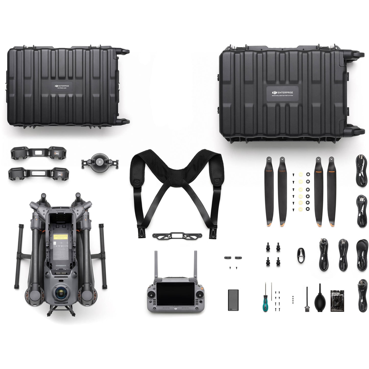
Packaging
- 1 × DJI Matrice 400 Aircraft
- 1 × RC Plus Remote Controller
- 2 × TB100 Intelligent Flight Batteries
- 1 × Charging Hub
- Propellers, Tools, and Documentation
Specs
Aircraft
Takeoff Weight (with propellers):
With Batteries: 9740±40 g
The actual product weight may vary due to differences in batch materials and external factors.
Max Takeoff Weight:15.8 kg
Dimensions:
Folded: 490×490×480 mm (L×W×H) (with landing gear and gimbal)
Maximum dimensions excluding propellers.
Aircraft carrying case dimensions: 779×363×528 mm (L×W×H)
Max Payload:6 kg
The 6 kg payload is measured at the third gimbal connector under sea level conditions. Payload capacity decreases as altitude increases. For details, refer to the official user manual.
Propeller Size:25 inches
Diagonal Wheelbase:1070 mm
Max Ascent Speed:10 m/s
Max Descent Speed:8 m/s
Max Horizontal Speed (at sea level, no wind):25 m/s
Max Takeoff Altitude:7000 m
Max Flight Time (no wind):59 minutes
Measured with the aircraft flying forward at a constant speed of 10 m/s in a windless environment at sea level, carrying only the H30T (total weight 10,670 g), and from 100% battery level until 0%. Data is for reference only. Actual experience may vary depending on the environment, usage, and firmware version.
Max Hover Time (no wind):53 minutes
Measured with the aircraft hovering in a windless environment at sea level, carrying only the H30T (total weight 10,670 g), and from 100% battery level until 0%. Data is for reference only. Actual usage time may vary depending on the environment, usage, and firmware version.
Max Flight Distance (no wind):49 km
Measured by the aircraft flying forward at a constant speed of 17 m/s in a windless environment at sea level, carrying only the H30T (total weight 10,670 g), and from 100% battery level until 0%. Actual experience may vary depending on the environment, usage, and firmware version.
Max Wind Speed Resistance:12 m/s
Max wind speed resistance during takeoff and landing.
Max Yaw Angular Velocity:Yaw: 100°/s
Max Pitch Angle:35°
Operating Temperature:-20° to 50° C (-4° to 122° F) (without solar radiation)
Global Navigation Satellite System (GNSS):GPS + Galileo + BeiDou + GLONASS*
* GLONASS is supported only when the RTK module is enabled.
Equipped with standard airborne ADS-B In receiver and dual antennas, supporting reception up to 20 km.
Hovering Accuracy Range (with moderate or no wind):
±0.1 m (with vision positioning)
±0.5 m (with satellite positioning)
±0.1 m (with RTK positioning)
Horizontal:
±0.3 m (with vision positioning)
±0.5 m (with satellite positioning)
±0.1 m (with RTK positioning)
RTK GNSS Accuracy:
RTK Fix:
1 cm + 1 ppm (horizontal), 1.5 cm + 1 ppm (vertical)
RTK Heading:Supports RTK heading with an accuracy better than 2°
Airborne ADS-B In:
Internal Storage:N/A
Ports:
E-Port V2 × 4: At the lower part of the drone, with 120W single-port power
Cellular Dongle 2 Interface × 2: On the underside of the drone
Propeller Model:2510F
Beacon:Built into the aircraft
Ingress Protection Rating:IP55
The rating is not permanently effective and may decrease due to product wear and tear.
Motor Model:7510
Gimbal:
Maximum Payload for Single Gimbal Connector:1400 g
If exceeds 950 g, the gimbal damper lifespan will decrease from 1000 hours to 400 hours.
Maximum Payload for Dual Gimbal Connector:950 g
Maximum Payload for Third Gimbal Connector:
Maximum Payload for Zenmuse L3 Gimbal Connector:2100 g
If exceeds 1600 g, the gimbal damper lifespan will decrease from 1000 hours to 400 hours.
Sensing
Sensing Type:
Horizontal rotating LiDAR, upper LiDAR, and downward 3D infrared range sensor
Six-direction mmWave radar
Forward:
Detection Range: 0.4-200 m
Field of View (FOV): 90° (horizontal), 90° (vertical)
Backward:
Detection Range: 0.4-200 m
Field of View (FOV): 90° (horizontal), 90° (vertical)
Lateral:
Detection Range: 0.5-200 m
Field of View (FOV): 90° (horizontal), 90° (vertical)
Downward:
The FOV to the front and rear is 160° and 105° to the right and left.
Operating Environment:
Delicate texture on the surface, adequate light.
Downward:
The ground has rich textures and sufficient lighting conditions*, with a diffuse reflection surface and a reflectivity greater than 20% (such as walls, trees, people, etc.).
* Sufficient lighting conditions refer to an illuminance not lower than that of a nighttime city light scene.
Rotating LiDAR:
Measurement Range for Power Line: 35 m @ 30° @ 10,000 lux for 21.6 mm steel-core aluminum stranded wire with a relative body tilt angle of 30° to the left and right
Field of View (FOV): 360° (horizontal), 58° (vertical)
Point-Frequency: 520,000 points/second
Laser Wavelength: 905 nm
Eye Safety Level: Class 1 (IEC60825-1:2014), eye-safe
Upper LiDAR (3D ToF):
The FOV to the up and down is 60° and 60° to the right and left.
Downward 3D Infrared Range Sensor:
The FOV to the front and rear is 60° and 60° to the right and left.
mmWave Radar:
36 m for a 12mm steel-core aluminum stranded wire
50 m for a 21.6mm steel-core aluminum stranded wire
FOV: ± 45° (horizontal and vertical)
The mmWave radar function may be unavailable or restricted in some countries or regions. Refer to local laws and regulations for more information.
FPV Camera
Resolution:1080p
Field of View (FOV):
HFOV: 139.6°
VFOV: 95.3°
Frame Rate:30fps
Night Vision:Starlight Grade
Video Transmission
Video Transmission System:DJI O4 Enterprise Enhanced Video Transmission System
Live View Quality:Remote Controller: 3-channel 1080p/30fps
Operating Frequency and Transmitter Power (EIRP):
1.430-1.444 GHz: < 35 dBm (SRRC)
2.4000-2.4835 GHz: < 33 dBm (FCC), < 20 dBm (CE/SRRC/MIC)
5.150-5.250 GHz: < 23 dBm (FCC/CE)
5.725-5.850 GHz: < 33 dBm (FCC), < 14 dBm (CE), < 30 dBm (SRRC)
Operating frequency allowed varies among countries and regions. Refer to local laws and regulations for more information.
Max Transmission Distance (unobstructed, free of interference):
20 km (CE/SRRC/MIC)
Measured in an unobstructed environment free of interference. The above data shows the farthest communication range for one-way, non-return flights under each standard. During your flight, please pay attention to RTH reminder on the DJI Pilot 2 app.
Max Transmission Distance (with interference):
Medium interference (suburban counties, city parks, etc.): approx. 6-15 km
Weak interference (open spaces, remote areas, etc.): approx. 15-40 km
Data is tested under FCC standard in unobstructed environments of typical interference. Only to serve as a reference and provides no guarantee as to the actual flight distance.
Max Download Speed:
Playback Download: < 25 MBps
Single-Channel Bitrate: ≤ 12 Mbps
The above data was measured under conditions where the aircraft and remote controller were in close proximity without interference.
Antenna:
sub2G Antenna × 2: 2 vertically polarized antennas
4G Antenna × 4
Operating Mode: 2T4R
Others:
Battery
Model:TB100
Capacity:20254 mAh
Standard Voltage:48.23 V
Max Charging Voltage:54.6 V
Cell Type:Li-ion 13S
Energy:977 Wh
Weight:4720 ± 20 g
Charging Temperature:5° to 45° C (41° to 113° F)
Discharging Temperature:-20° to 75° C (-4° to 167° F)
Battery Heating:
Onboard: Support
Battery Station: Support
Discharge Rate:4C
Max Charging Power:2C
Low-Temperature Charging:Supports low-temperature self-heating charging
Cycle Count:400
Intelligent Battery Station
Model:BS100
Net Weight:11.8 kg
Dimensions:605×410×250 mm (L×W×H)
Supported Batteries:
WB37 Battery
Operating Temperature:-20° to 40° C (-4° to 104° F)
Input:100-240 V (AC), 50-60 Hz, 10 A
Output:
100-110 V: Approx. 1185 W
110-180 V: Approx.1474 W
180-240 V: Approx. 2184 W
WB37 Battery Interface:
100-240 V: Approx. 52 W
USB-C:
5.0 V 3.0 A, 9.0 V 3.0 A, 12.0 V 3.0 A, 15.0 V 3.0 A, 20.0 V 3.25 A
Number of Charging Channels:
Charging Mode:
Supports Fast Charging Mode and Silent Mode
Charging Time:
220 V: 45 minutes (Fast Charging Mode); 110 minutes (Silent Mode)
110 V: 70 minutes (Fast Charging Mode); 110 minutes (Silent Mode)
Charging time is measured in a test environment with a temperature of 25° C (77° F).
DJI RC Plus 2 Enterprise Enhanced
Video Transmission System:
Max Transmission Distance (unobstructed, free of interference):
20 km (CE/SRRC/MIC)
Measured in an unobstructed environment free of interference. The above data shows the farthest communication range for one-way, non-return flights under each standard. During your flight, please pay attention to RTH reminder on the DJI Pilot 2 app.
Video Transmission Operating Frequency and Transmitter Power (EIRP):
2.400-2.4835 GHz: < 33 dBm (FCC), < 20 dBm (CE/SRRC/MIC)
5.150-5.250 GHz: < 23 dBm (FCC/CE)
5.725-5.850 GHz: < 33 dBm (FCC), < 14 dBm (CE), < 30 dBm (SRRC)
Operating frequency allowed varies among countries and regions. Refer to local laws and regulations for more information.
Antenna:
sub2G Module: 2T2R
Enhanced Transmission:Supports DJI Cellular Dongle 2
Wi-Fi Protocol:
Supports 2×2 MIMO Wi-Fi, dual-band simultaneous (DBS) support for dual MAC, with data rates up to 1774.5 Mbps (2×2 + 2×2 11ax dual-band simultaneous)
Wi-Fi Operating Frequency:
5.150-5.250 GHz
5.725-5.850 GHz
5.2 and 5.8GHz frequencies are prohibited in some countries. In some countries, the 5.2GHz frequency is only allowed for use in indoor. Refer to local laws and regulations for more information.
Wi-Fi Transmitter Power (EIRP):
5.1 GHz: < 23 dBm (FCC/CE/SRRC/MIC)
5.8 GHz: < 23 dBm (FCC/SRRC), < 14 dBm (CE)
Bluetooth Protocol:Bluetooth 5.2
Bluetooth Operating Frequency:2.400-2.4835 GHz
Bluetooth Transmitter Power (EIRP):< 10 dBm
Screen Resolution:1920 × 1200
Screen Size:7.02 inches
Screen Frame Rate:60fps
Brightness:1400 nits
Touchscreen Control:10-Point Multi-Touch
Built-in Battery:
External Battery:Optional, WB37 (4920 mAh @ 7.6 V) 37 Wh
Charging Type:
Storage Capacity:RAM 8G + ROM 128G UFS + expandable storage via microSD card
Charging Time:2 hours for internal battery; 2 hours for internal plus external batteries.
When remote controller is powered off and using a standard DJI charger.
Internal Battery Runtime:3.8 hours
External Battery Runtime:3.2 hours
Output Port:HDMI 1.4
Indicators:
Speaker:Supports buzzer
Audio:Array MIC
Operating Temperature:-20° to 50° C (-4° to 122° F)
Storage Temperature:
One to three months: -30° to 35° C (-22° to 113° F)
Three months to one year: -30° to 30° C (-22° to 86° F)
Charging Temperature:5° to 40° C (41° to 104° F)
Supported Aircraft Model:Matrice 400
Global Navigation Satellite System:GPS + Galileo + BeiDou
Dimensions:268×163×94.5 mm (L×W×H)
Width including external antenna folded, thickness including handle and controller sticks.
Weight:1.15 kg (without external battery)
Model:TKPL 2
System Version:Android 11
External Interfaces:
Accessories:Strap/waist support
Supported Products
DJI Products Compatible With Matrice 400:
Accessories: Zenmuse S1 (drone spotlight), Zenmuse V1 (drone speaker), Manifold 3, DJI RC Plus 2 sub2G SDR Module*, DJI Cellular Dongle 2
RTK Station: D-RTK 3 Multifunctional Station, D-RTK 2 Mobile Station
Ecosystem Accessories: DJI X-Port
DJI E-Port V2 Development Kit
DJI E-Port V2 Coaxial Cable Kit
DJI SKYPORT V3 Adapter Set
DJI SKYPORT V3 Coaxial Cable Kit
* Operating frequency allowed varies among countries and regions. Refer to local laws and regulations for more information.
Shipping Policy
We are committed to providing reliable and efficient shipping for professional and enterprise customers across the United States.
U.S. Warehouse Fulfillment
All orders are shipped from our Los Angeles, California warehouse.
Our local inventory allows us to respond quickly to customer needs and maintain stable product availability.
Order Processing Time
Most orders are processed within 0–1 business day after payment confirmation.
Orders placed outside business hours, on weekends, or during holidays will be processed on the next business day.
For large orders or specialized equipment, processing time may vary. Our team will notify you if additional preparation time is required.
Estimated Delivery Time
Delivery times depend on the destination and carrier.
Typical transit times within the United States:
-
West Coast: 1–2 business days
-
Central Region: 2–4 business days
-
East Coast: 3–5 business days
Please note that these are estimated delivery windows and may vary due to carrier operations or external conditions.
Shipping Carriers
We partner with trusted logistics providers to ensure safe and timely delivery, including:
-
UPS
-
FedEx
-
DHL
-
USPS (for smaller shipments)
Carrier selection is based on package size, delivery location, and service availability.
Inventory Availability
We maintain stable inventory levels for core products to support enterprise and professional users.
If a product is temporarily out of stock or requires additional lead time, our sales team will inform you promptly.
Shipping Issues
If your shipment is delayed, damaged, or lost in transit, please contact our support team as soon as possible. We will work with the carrier to resolve the issue.
Contact
For logistics questions, enterprise orders, or project-based procurement, please contact our team.
Email: contact@aerialsystemssupply.com
Business Hours: Monday – Friday
U.S. Warehouse
Our products are stocked and shipped directly from our Los Angeles warehouse, allowing us to provide fast and dependable delivery across the United States.
Unlike overseas fulfillment, local inventory ensures quicker processing, shorter transit times, and more reliable availability for professional users.
Local Inventory Advantage
Having a U.S.-based warehouse allows us to better serve commercial and enterprise customers who rely on consistent equipment supply.
Key benefits include:
• Faster order processing
• Reduced shipping time
• Reliable product availability
• Safer and more stable logistics
This is especially important for industries where timing and equipment readiness are critical.
Shipping Coverage Across the United States
Orders shipped from our Los Angeles warehouse typically arrive within:
West Coast
1–2 Business Days
Central U.S.
2–4 Business Days
East Coast
3–5 Business Days
Delivery times may vary depending on carrier operations and destination.
Built for Enterprise and Professional Users
We understand that many of our customers rely on drones for daily operations such as:
• Public safety
• Infrastructure inspection
• Surveying and mapping
• Construction
• Energy and utilities
Our local warehouse helps ensure that equipment and accessories are available when they are needed.
Reliable Stock Availability
We maintain stable inventory levels for core drone platforms, payloads, and accessories.
This allows us to support both individual orders and larger procurement requests.
For bulk purchases or project-based orders, our team can help coordinate supply and logistics.
Need Equipment Quickly?
If you need assistance selecting products or arranging delivery for a project, our team is here to help.
Contact us for product availability and shipping support.
Matrice 400 Series
-
 Sold out
DJI Matrice 400 Drone
Regular price $10,450.00Regular price -
 Sold out
DJI Zenmuse L2
Regular price $15,490.00Regular price -
 Sold out
DJI Zenmuse S1 Spotlight
Regular price $1,719.00Regular price -
DJI Zenmuse L3 LiDAR Camera
Regular price $17,400.00Regular price


